Do you need a financi Read more [...]
Spanish Main Mineral Property
Project Category: Exploration
-
Spanish Main Mineral Property Overview
40 Acre Lode and Placer Claim – Red River District – Taos County, New Mexico
Introduction:
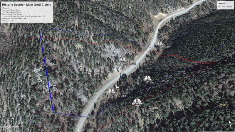
The Spanish Main, or “Govenors Mine” as it has also been known is located in the Red River Mining District of Taos County, New Mexico. The mines are contained within a twenty (20) acre lode mining claim. There is also an associated twenty (20) acre placer mine which overlaps some of the boundaries of the lode claim. There is a single adit on the lode claim that can be reached by scaling a short wall to the entrance. Opposite of this portal is the Red River for which the district is named. This river is known for its placer gold production, however there is little record of any major work or recovery in placer mining of the area.
The Mines are notable for their long history and questionable origins. The Spanish Main was noted in early documentation as “the Govenors Mine”, a key Spanish Mine working noted as being east of the Questa settlement. The mine was reportedly very rich in native gold deposits and paid taxes to the Queen (Empire of Spain) in the amount of ten thousand ($10,000) dollars per month
In or around 1770, the local Taos Indians revolted against Spanish slavery forcing their work in the mines and drove the Spanish miners from the area. The Indians then backfilled the mine completely.
In or around 1896, the mine was re-discovered, and work was begun on excavating the workings. This work continued until 1922 when the main drift and cavern had been exposed. Carbon and burn marks were noted in the main stope, evidence of fires operating inside the mine. This also coincided with reports from natives who said their ancestors were left inside the mine for weeks on end and slept in a communal room inside the mine under Spanish guard.
From 1922 to 1960 there is no record of any work in the Mine. In 1960 Schelling reported the portal was again blocked but showed no evidence of mineralization from his visual inspection.
Locals in the town of Red River report that in 1980, a group of three (3) men placed a claim on the site and began again excavating the old workings. There is no further information on development or forther work at the site.
Gold Rush Expeditions, Inc. surveyors found there to be substantial iron mixed with quartz veins at the site. Inside the mine there are also quartz veins which seem to follow an assumed fault which the mine workings are cut on. Inside the mine there is a large stoped room, this room has two drifts which lead off at opposite ends of the room, these drifts seem to follow the fault as well. One of these drifts is mostly full of stagnant water. The other drift has been filled in with rock and dirt from outside the mine. There is some timber work visible among the rock and dirt fill.
The area is remote and accessible for only a few months out of the year which may account for some of the lack of development. At its elevation, winter comes early, October is common, and the snows do not melt off until April.
Property Description:
The lode claim is laid out to work up the hillside where other possible portals are likely located. This lode claim covers all of the area including some overlap with the place claim which covers the Red River as it runs by the lode mine. The portal of the mine is located at 9325 elevation. The claims, both lode and placer exist at roughly 9300’. There is alpine vegetation such as Aspens and other small trees. Some pines are visible higher up the slopes of the canyon.
The property can be accessed by most any 2WD vehicle and provides a good staging and parking area just off the State Route.
Qualified Clients Call or Email for a Full GRMP-43 Technical Mine Report.
-
Total Resource Estimate (M+I+I): ZERO
-

